")
")
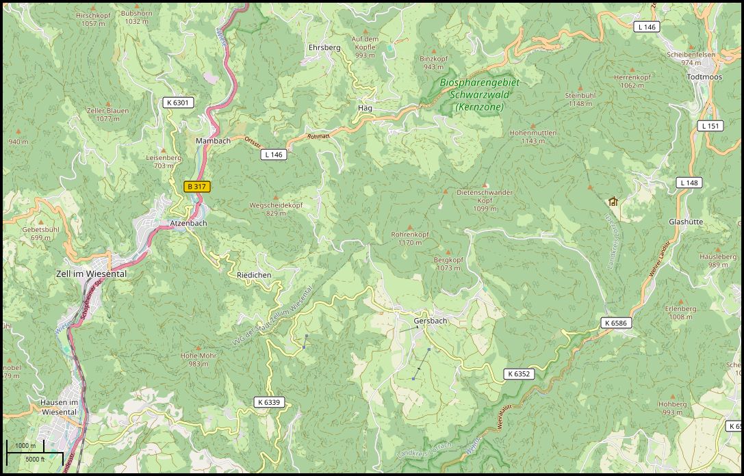
Map showing location and access to the ruins
List of castle ruins
🏰 Castle Ruin Turmhoelzle
| Name | GPS | Type | Height | Preserv. |
|---|---|---|---|---|
| C. Ruin Turmhölzle 79650 Schopfheim-Raitbach |
47.6831° N, |
castle build on a hill | 620m | Castle mound, neck and ring ditch, remains of the keep, curtain wall and other buildings |
-
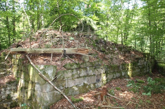
 View across the castle grounds to the east: Remains of the curtain wall to the front left, inner buildings and keep in the background. Photo: W. Richter
Existing Situation
The Turmhölzle castle ruins are among the best-preserved castle ruins in the district of Lörrach. It is situated on an oval hilltop at the end of a mountain spur on the southern slope of the Hohe Möhr to the east of the upper village of Raitbach, a district of the town of Schopfheim. The castle ruins occupy almost the entire summit plateau of the hilltop. It extends over approx. 35 metres in an east-west direction and approx. 18 metres at its widest point in a north-south direction. It has a total area of approx. 600 m2.
 Full width of the keep facing south. Photo: W. Richter
 Large, smoothly dressed ashlars laid in courses at the southwest corner of the keep. The use of smoothly dressed ashlars gave the keep a stately appearance. Photo: W. Richter
 On the east side of the keep, which was once concealed by the curtain wall, rough-hewn fieldstones were used instead of smooth ashlars. In the foreground, the upper edge of the curtain wall ruins is visible. Photo: W. Richter
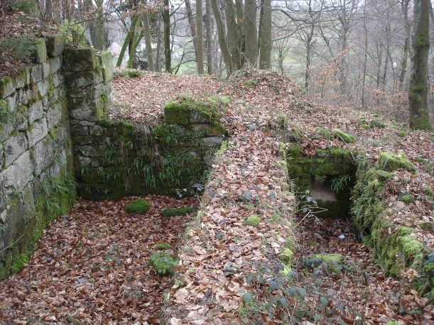 On the left of the picture are the remains of the door/threshold to the first floor of the palace. View from inside the palace. The keep wall on the left edge of the picture. Photo: W. Richter
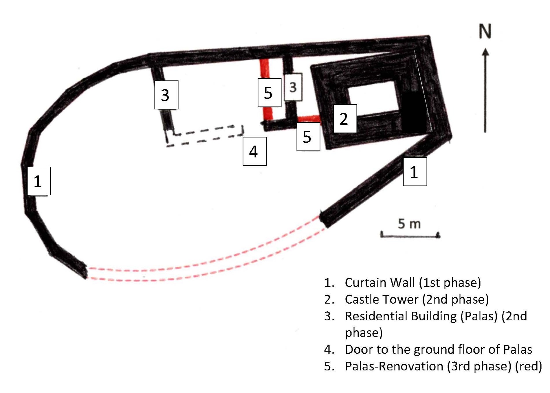 Ground plan of the castle ruin, GPS survey: Stadtmuseum Schopfheim, drawing of the ground plan W. Richter
1st construction phase
The curtain wall (1) was built at the beginning of construction and is between 0.8 and 1.2 metres thick. It was excavated on the east and north sides of the castle in 1981. The outer face of the curtain wall is constructed in hammer-dressed coursed masonry. In the west, the curtain wall can be seen along the edge of the summit plateau, partly due to the moss-covered stones. On the south side, the course of the curtain wall is largely unclear, as this area has not yet been archaeologically investigated. The castle gate, whose location is still unknown, is also thought to be in this area.
2nd construction phase
In the eastern part of the castle grounds are the remains of the rectangular castle tower/keep (2) with a floor area of 9.5 x 7.5 m and walls approximately 2.5 m thick. The keep is directly adjacent to the castle's curtain wall on the eastern side. The exterior of the keep is constructed in carefully dressed ashlar of varying size with smoothed faces (flat ashlars), giving the tower a representative appearance. Only on the eastern side, where the keep abuts the curtain wall, were simple dressed stones used. The use of flat ashlars in the construction of keeps is largely confined to early castles, as by the late 12th century bossed ashlar became the prevailing technique in keep construction.
Adjacent to the keep on the west side are the remains of what is believed to be the main (residential) building (palas), the palas (3) of the castle. Two construction phases can be distinguished in the palas: in the initial construction phase, the palas was separate from the keep. The gate to the ground floor of the palas (4) is still visible.3rd construction phase
The palas was extended and rebuilt in a later construction phase. The eastern wall from the initial construction phase was demolished down to the ground floor and new walls (5) were erected (red in the plan). The palas was thus extended and reached as far as the keep. The upper edges of the wall remains in the area of the extension (5) correspond approximately to the upper edge of the ground floor. Directly next to the keep are the remains of a door that led to the first floor of the extended palas. The door was probably accessible via a wooden staircase.
The buildings in the western and southern part of the castle are unknown, as this part of the castle grounds has not yet been archaeologically investigated.
Ditches and ramparts are visible around the hilltop. To the east, the hilltop is separated from the rest of the spur by a neck ditch. To the north and west, the hilltop is protected by a ring ditch with a partially polished rampart in front of it.
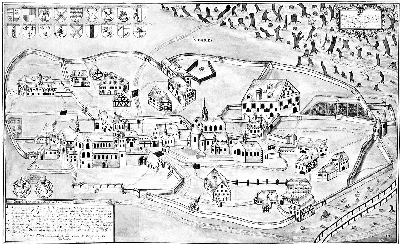 View of St. Blasien Abbey around 1562. From L. Schmieder: Das Benediktinerkloster St. Blasien. Augsburg 1929. Fig. 17., Public domain, Link
History
No direct historical information about the castle has yet been found. The name "Turmhölzle" is not the original name of the castle in the Middle Ages. "Fernegg" or "Farnegg" has been suggested as the original castle name on the basis of field names in property descriptions of the monastery of St. Blasien, which had estates in Raitbach (Schubring 1986).
As there are no historical records, the castle's construction history can only be deduced from archaeological findings. Examination of the ruins has shown that the castle's construction history comprises three periods:
Period 1
The castle was initially built as a so-called curtain wall castle, i.e. it did not have a castle tower. The buildings within the cuetain wall from this phase have not yet been archaeologically recorded. Beam holes in the curtain wall indicate a larger building in the north-east corner of the castle. Based on findings in contemporary castles in north-western Switzerland, the buildings may have been constructed of wood or half-timbered. The castle was probably built in the 11th or early 12th century. If further investigations confirm that it was built in the 11th century, the Lords of Waldeck may have been the builders.
The construction of early castles as curtain wall castles does not seem to be unusual in the region. The absence of a tower is typical of early castles in the canton of Aargau (Frei 2023). In other areas, however, the residential tower seems to have been the preferred design in the 11th century. A study of castles from this period (the Salian period) in Hesse, Rhineland-Palatinate and Saarland showed that ‘around 80% of all early noble castles examined had a more or less imposing stone or wooden tower’ (Böhme 1991).Period 2
In a second phase of construction, the keep and a stone main building (palas) were erected. The masonry of the keep indicates that it was built in the 12th century (Meyer 1981). With these changes, the Turmhölzle castle corresponded to the image of ‘classical’ noble castles with a keep and separate residential building, which began to appear in the second half of the 12th century (Biller 1998). The castle was probably rebuilt by a ministerial of the monastery of St. Blasien to protect the monastic lordship in this area. Raitbach belonged to the Fahrnau-Raitbach estate of the monastery of St. Blasien (Schubring 2000).
Period 3
The palace building was rebuilt and extended towards the keep (see also the castle floor plan).
More precise information about the end of the castle is lacking. The pottery found suggests that the castle was abandoned as early as the first half of the 13th century. It remains unclear whether the charred pieces of clay found during the excavation indicate that the castle was destroyed by fire. However, it is also possible that the end of the castle is linked to changes in ownership in Raitbach. The Lords of Stein (Herren von Stein) gained influence in Raitbach and built the nearby Neuenstein Castle (now the Ruine Burgholz), which was first mentioned in documents in 1283 (Schubring 2000).
Excavation of the castle
In 1981, the eastern part of the castle with the keep was excavated by school groups under the guidance of archaeologists on the initiative of the town of Schopfheim. Most of the remains of the walls now visible came to light during this excavation.
In 1982, the State Monuments Office stopped further excavations before the excavated walls were properly conserved and secured. No conservation of these walls has yet taken place.
As the excavation of the castle could not be continued, many questions about the layout, the building history and the beginning and end of the castle remained unanswered.
Endangerment of the castle ruins
 Remains of the ring wall on the east side of the castle: Before the excavation in 2018. Photo: W. Richter
 Decay of the curtain wall on the east side of the castle: wall collapse from 2022. Photo: W. Richter
 Remains of the ring wall after the reversible reconstruction in October 2024. Photo: W. Richter
The sections of wall uncovered during the 1981 excavation were not preserved at the time. In the meantime, the exposed walls have begun to decay. In 2022, for example, there was a major wall collapse on the east side of the curtain wall. Significant decay is also visible on parts of the interior buildings.
It is to be expected that without conservation of the walls, the decay will continue and could lead to the long-term loss of this remarkable castle ruin.
How to get there
Literature
Thomas Biller, Die Adelsburg in Deutschland / Entstehung-Gestalt-Bedeutung, München, 1998, S. 134 Digitalisat der UB Heidelberg, Th.B.
Horst Wolfgang Böhme, Burgen der Salierzeit in Hessen, in Rheinland-Pfalz und im Saarland, in: Horst Wolfgang Böhme (Hg.), Burgen der Salierzeit/Teil 2/In den südlichen Landschaften des Reiches, Sigmaringen 1991, S. 69 Digitalisat der UB Heidelberg, H.W.B.
Peter Frey, Die Burgen des Kantons Aargau / Mittelalterliche Adelssitze, Brugg 2023, S. 29 Digitalisat der UB Bern, P.F.
Werner Meyer, Burgen von A bis Z – Burgenlexikon der Regio, Basel 1981. S. 35
Klaus Schubring, Ein älterer Name für das Turmhölzle in Raitbach – Eine Ruine gibt Fragen auf, in: Jahrbuch ´86 Stadt Schopfheim, S. 62-69.
Klaus Schubring, Bauern, Mönche und Adlige, in: Schopfheim - Natur, Geschichte, Kultur, Schopfheim, 2000. S. 101-120.
C.A. Müller, Burgen und Schlösser, in: Das Markgräflerland, Jahrgang 4/35, Sonderheft 1973. S. 61 Digitalisat der UB Freiburg, C.A.M.

🏰 Castle Ruin Altenstein
| Name | GPS | Type | Height | Preserv. |
|---|---|---|---|---|
| C. Ruin Altenstein 79685 Häg-Ehrsberg |
47.7333° N, |
castle build on a hill | 740m | Neck ditch, few traces of walls (most of the castle area has slipped into the Angenbach valley) |
-
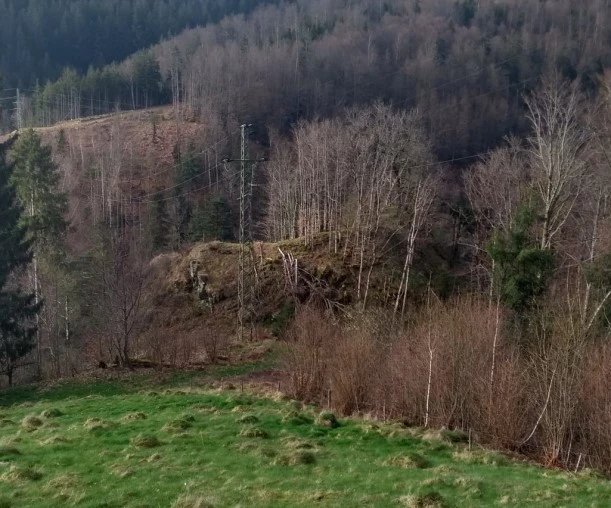 Altenstein castle site: View from the south towards the Angenbach valley. Deep neck ditch behind the electricity pylon, with the castle grounds behind it. Remains of the southern curtain wall in the visible ridge on the castle grounds. Foto: Wolfgang Richter
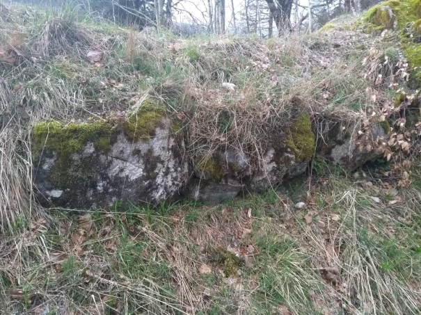 Remains of the southern curtain wall. Foto: Wolfgang Richter
The castle ruins
The castle site of the Altenstein ruins is located not far from the hamlet of Altenstein in the municipality of Häg-Ehrsberg on a mountain spur that extends into the Angenbach valley. On the south side, the mountain spur is separated by an approx. 8 m deep neck ditch; on the west, north and east sides, the mountain spur falls almost vertically into the Angenbach valley (Bigott 2009). There are small remains of a curtain wall along the ditch (Meyer 1981). The castle area has probably partially slipped into the Angenbach valley.
History
The castle was probably built in the 12th or 13th century. Nothing is known about the end of the castle.
It is unclear whether it is the documented Altenstein Castle, the presumed ancestral seat of the Lords of Stein. Based on the existing documents from the 14th century and other evidence, Schubring assumes that it is the documented Altenstein Castle (Schubring 2012). Meyer and Bigott, on the other hand, assume that the documented Altenstein Castle is the Henschenberg ruins near Zell im Wiesental (Bigott 2009, Meyer 1981) (see also Henschenberg ruins).
Altenstein Castle, which is mentioned in a document, was probably only called Stein at first. After Neuenstein Castle was built by the lords of Stein, it was called Altenstein to differentiate it from Neuenstein Castle. Neuenstein Castle was first mentioned in 1283. Altenstein Castle must therefore have already existed in the second half of the 13th century. Altenstein was presumably an official castle of Säckingen Abbey, which was given as a fief to the Lords of Stein as the abbey's masters and served as an administrative centre (Gutmann 2013). According to a document from 1421, it had evidently lost its function as an administrative centre by this time (Gutmann 2013).
©OpenStreetMap contributors. DR. DSGVOGetting there by 🚗 and by 🥾
From 79685 Häg-Ehrsberg to the Altenstein district. The ruin is located below the Altenstein district. Access to the ruin is very difficult, as there is no foot path to the ruin. Very steep ascend from the neck ditch to the castle area.
Literature
Boris Bigott: Häg (Häg-Ehrsberg. LÖ). In: Alfons Zettler, Thomas Zotz: Die Burgen im mittelalterlichen Breisgau, II. Südlicher Teil: Halbband A-K. Jan Thorbecke Verlag, Ostfildern 2009, ISBN 978-3-7995-7366-5, S. 244–247. Digitalisat der UB Heidelberg, B.B.
Andre Gutmann: Unter dem Wappen der Fidel – Die Herren von Wieladingen und die Herren vom Stein zwischen Ministerialität und adliger Herrschaft. Verlag Karl Alber Freiburg / München 2011, S.321-322 Online-Veröffentlichung 2013 .
Werner Meyer: Burgen von A bis Z – Burgenlexikon der Regio, Basel 1981. S. 9
Klaus Schubring: Wo lag die Burg Altenstein? In: Das Markgräflerland, Band 1/2012, S. 106–117. Digitalisat der UB Freiburg, K.Sch.
🏰 Castle Ruin Burgholz
| Name | GPS | Type | Height | Preserv. |
|---|---|---|---|---|
| C. Ruin Burgholz 79650 Schopfheim-Raitbach |
47.6776° N, |
castle build on a hill | 663m |
Castle mound, few remains of walls, neck ditch and ring ditch |
-
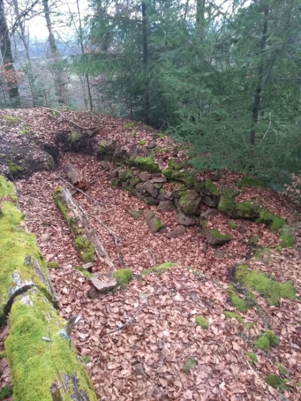 Remains of the wall at the south-west corner of the core castle, photo: Wolfgang Richter
The castle ruins
The ruins of Burgholz are located near the village of Raitbach, a district of the town of Schopfheim.
Close to the Raitbach - Schweigmatt road lie the "sparse remains of an extensive castle complex on a steep, rocky hilltop" (Meyer 1981). On the northern side there is a two-part outwork (see ground plan). A deep neck ditch, partly cut into the rock, separates the outer bailey from the core castle. Only small remains of the walls of the core castle have survived. Possibly the remains of a round tower at the north-east corner. To the south of the core castle is an outer bailey with the old entrance to the castle. The core castle and southern outer bailey are surrounded by a moat with a rampart in front of it.
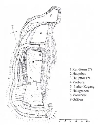 Ground plan of the ruins of Burgholz (from Schubring 1994, p. 55)
History of the castle
First mentioned in 1283: The Burgholz ruins are probably the ruins of Neuenstein Castle (Schubring 1994). This was built by the Lords of Stein and first mentioned in 1283. The brothers Rudolf and Heinrich von dem Steine made an endowment for their salvation at their castle "zu dem Nuwenstaine" in 1283. In the middle of the 14th century, the male line of the Lords of Stein died out and the Lords of Schönau inherited their property (Schubring 2001).
In 1400, Anna von Klingenberg, the widow of the knight Rudolf Hürus d.A. von Schönau, and her son Albrecht von Schönau sell the fortress "Nuw Stein" with the surrounding villages of Gersbach, Schlechtbach, Schweigmatt, Kürnberg and Raitbach as well as several farms to Margrave Rudolf III von Hachberg-Sausenberg. In 1401, St. Blasien renounces its fiefdom rights to the castle.
In 1509, the castle is in ruins. In this year, Margrave Christoph von Baden enfeoffs Appolinaris Höcklin von Schopfheim with the Burgstadel, i.e. the castle was already in ruins at this time. At this time, the castle barn is called Steineck. It was not until the 17th century that the name Burgholz became established (Schubring 1994).
Map
©OpenStreetMap contributors. DR. DSGVOHow to get there
How to get there by 🚗
Coming from 79650 Schopfheim-Raitbach, the castle ruins are located close to the K 6339 in a sharp left-hand bend, about halfway between the Raitbach districts of Scheuermatt and Steinighof. You can park directly at the edge of the forest below the castle hill. The castle ruins are difficult to access as there are no paths or trails leading up to the steep castle hill.
Getting there by 🚈 and by 🥾
From Hausen-Raitbach railway station, take the hiking trail in the direction of Raitbach/Schweigmatt. Continue past the Turmhölzle ruins in the direction of Schweigmatt. In the hamlet of Blumberg, turn right onto the downhill track to the Raitbach-Schweigmatt road (K6339). The castle hill is on the opposite side of the road.
Literature
Werner Meyer, Burgen von A bis Z – Burgenlexikon der Regio, Basel 1981. S. 13
Klaus Schubring: Die Herrschaft Neuenstein und Hausen im Wiesental. In: Das Markgräflerland, Heft 1, 1994, S. 43-62. Digitalisat der UB Freiburg, K.Sch.94
Klaus Schubring: Die genealogische Entwicklung der Familie. In: Wernher von Schönau und Katharina Frings (Hrsg.): Adel an Ober- und Hochrhein – Beiträge zur Geschichte der Freiherren von Schönau. Freiburg im Breisgau 2001, ISBN 3-7930-9282-8, S. 75–98.
🏰 Castle Ruin Henschenberg
| Name | GPS | Type | Height | Preser. |
|---|---|---|---|---|
| C. Ruin Henschenberg 79669 Zell im Wiesental |
47.7084° N |
castle build on a hill | 498m |
Castle mound, few remains of walls, neck ditch |
-
 Zieglhar, Ruine Henschenberg 1, CC BY-SA 4.0
 The castle ruins
The Henschenberg ruins are located on a mountain spur to the west of the town of Zell im Wiesental between Henschenbach and Fischbach. A striking neck ditch separates the castle area on the mountain side (ground plan in Müller 1973). Only small remains of walls can be found on the castle grounds. On the north side, adjacent to the moat, there are remains of a "larger, fortified building, probably a residential tower" (Meyer 1981). There are also remains of walls of other, unidentified buildings on the castle grounds. Werner Meyer reports late medieval beavertail tiles and pottery shards from the 14th and 15th centuries in the surface rubble on the entire castle site (Meyer 1981). A tunnel driven into the rock on the eastern side of the mountain spur is probably not connected with the castle.
History of the castle
There is no documentary evidence of Henschenberg Castle. However, some authors assume that it is the documented Altenstein Castle of the Lords of Stein (Meyer 1981, Bigott 2009), whereas other authors identify the Altenstein ruins near Häg-Ehrsberg as the documented Altenstein Castle (Schubring 2012) (see also under Altenstein ruins).
How to get there
How to get there by 🚗 and by 🥾
From 79669 Zell im Wiesental via Gresgener Weg (parking available in Scheffelstraße, for example). Take a short forest path along the Henschenbach stream to the ruins, which are located about 130 metres north of the confluence of the Fischbach and Henschenbach streams. The steep castle hill is difficult to access and there are no paths up to the castle hill.
Getting there by 🚈 and by 🥾
79669 Zell (Wiesental) is the terminus of the Wiesental railway.
Literature
Boris Bigott: Häg (Häg-Ehrsberg. LÖ). In: Alfons Zettler, Thomas Zotz: Die Burgen im mittelalterlichen Breisgau, II. Südlicher Teil: Halbband A-K. Jan Thorbecke Verlag, Ostfildern 2009, ISBN 978-3-7995-7366-5, S. 244–247. Digitalisat der UB Heidelberg, B.B.
Werner Meyer, Burgen von A bis Z – Burgenlexikon der Regio, Basel 1981. S. 16
C.A. Müller, Burgen und Schlösser, in: Das Markgräflerland, Jahrgang 4/35, Sonderheft 1973. S. 61 Digitalisat der UB Freiburg, C.A.M.
Klaus Schubring: Wo lag die Burg Altenstein? In: Das Markgräflerland, Band 1/2012, S. 106–117. Digitalisat der UB Freiburg, K.Sch.